
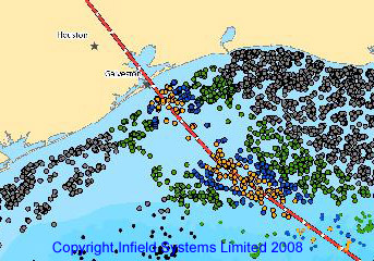
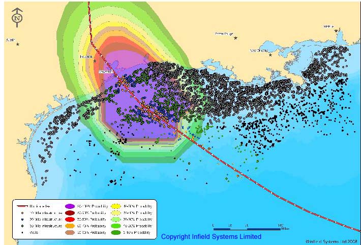
Infield were able to identify and track individual platforms, operators and participants at most risk. Hurricane Gustav was initially predicted to hit the Devils Tower platform and Thunderhorse but shifted west and missed these key platforms. .IKe reports from the Gulf indicate the Mad Dog and Ewing Banks 949 “Queen of Hearts” platforms to have been badly damaged and Stone's Vermillion platform destroyed. Houston based W&T confirmed that Eugene Island 371 B and 397 A platforms had been sunk by Hurricane Ike.
Infield's early analysis would indicate that a significant number of older but low output platforms were subjected to hurricane force winds. These older installations could have been damaged or destroyed. Infield can utilise it's extensive offshore databases and OFFPEX model to predict the most likely type of field layout to be employed where a platform has been destroyed and the supply resources required and the contraints and costs in replacing it.
Costs of damage caused by Ike are already estimated at between $7bn and $14bn and Gustav at $2.5 to $5bn.
Following hurricane Katrina in 2005 there was a widespread backlash from reinsurers and insurers regarding the accuracy of commercially available models at that time. It was presumed that this would lead to a reduction in reliance on modelling; however,usage has not only increased, but has spread more widely among rating agencies, regulators, and investors. Infield has developed the most accurate and complete database of offshore installations worldwide over the last 20 years and has now enhanced this using it's Energy Gateway GIS product in 2008 to produce the most complete tool for reinsurers and insurers.
For further information on how Infield can support your hurricane risk analysis using the most comprehensive Offshore installation database available please contact Infield.
The Infield Energy Gateway
Access to detailed Offshore oil and gas maps and GIS has been restricted to major corporations until now.
Infield Systems Limited, now widely acknowledged as one of the definitive independent information resources for the offshore oil and gas industry, are proud to announce the launch of a completely new and original online GIS mapping and data source.
The Infield EnergyGateway is a new,user friendly, practical mapping system based upon existing and well respected, in-house data resources. The system is the front end locator for multiple data layers of highly informative and client specific oil and gas data.
The GIS system is used to
- Support Client Forecasting
- Tendering Process
- Viewing of regional specific projects and campaigns.
The complete EnergyGateway system provides a full regional overview of both operational and future up-coming field locations, reserves and field infrastructure, including; licence blocks and current operator and field ownership, pipelines, fixed and floating production system platforms, water depths, oil and gas and on and offshore LNG terminals and facilities, Major Ports and Yards in addition to the regioal Major Cities, Towns and Country Median lines.
Infield intends to continue to research and enhance the GIS mapping system for offshore and onshore data to provide a full and detailled online mapping facility to improve all aspects of information required to support the offshore oil and gas industy and associated services.
Infield Energy Data Analysts
Infield has been providing accurate,
timely and detailed data and
information on the worldwide oil and
gas industry since 1986.
Now widely acknowledged as one of
the definitive independent reference
sources, Infield has developed a
range of products and services
designed to assist senior executives
with their business decisions. For
more information please visit www.infield.com. or visit the Infield online shop.
Download a pdf for a leaflet giving details of the Infield Energy Gateway.